Executive Summary
This 1971 single-story residence demonstrates good fire-resistant construction with clay tile roofing and stucco siding, both non-combustible materials with excellent ember resistance. The structure benefits from adequate separation distance to neighbors but faces elevated risk from dense surrounding vegetation coverage visible in the aerial imagery.
Location
Located in La Jolla, California, an affluent coastal community characterized by Mediterranean climate, chaparral and coastal sage scrub vegetation, and steep canyon terrain. The property sits in San Diego County's Very High Fire Hazard Severity Zone and is 0.46 miles (2451 ft) from a reservoir to the south. The area features a mix of residential development and preserved natural areas with significant wildland-urban interface exposure.
Fire History
The region has experienced several major wildfires including the 2003 Cedar Fire (273,246 acres, 2,820 structures destroyed), the 2007 Witch Fire (197,990 acres, 1,650 structures destroyed), and the 2014 San Diego County fires. More recently, the 2020 Valley Fire burned 17,665 acres in eastern San Diego County. These events demonstrate the ongoing wildfire threat to the greater San Diego region, with several fires reaching into urban interface areas similar to La Jolla.
Structure Analysis
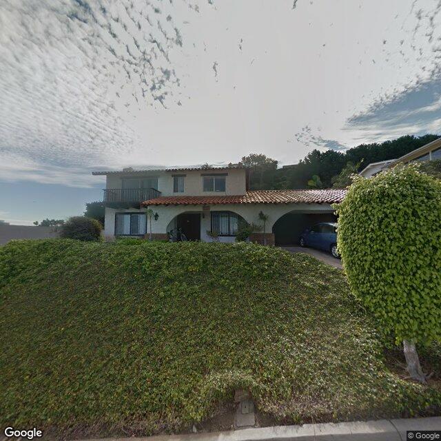
Street view of property
Measured Distances (from geospatial data)
| SSD: 31.8 ft (estimated)
| Coast: 0.46 mi to south (reservoir)
| Neighbors: 0 within 100ft
Click a factor to expand details. Scores: 0 = minimal risk, 10 = critical risk.
Red clay tile roofing visible in aerial image provides excellent ember resistance and Class A fire rating
Weight: 17%
Moderately complex roof with multiple planes and a small shed dormer, creating some ember accumulation areas
Weight: 6%
Roof appears in good condition for a 1971 structure, likely updated, with intact tile coverage
Weight: 6%
Clay tile roofing provides Class A fire rating with excellent ember resistance
Weight: 6%
White stucco siding visible, providing good fire resistance as a non-combustible material
Weight: 14%
Stucco exterior provides low flame spread characteristics and good fire resistance
Weight: 9%
Traditional exposed eaves visible with what appears to be standard soffit construction, moderate ember vulnerability
Weight: 9%
Standard residential windows visible, likely single-pane given 1971 construction, moderate vulnerability to radiant heat
Weight: 8%
No visible wooden decks or combustible attachments, minimal risk from structural attachments
Weight: 9%
Nearest neighbor at 31.8 ft provides moderate separation, well within safe distance for radiant heat protection
Weight: 11%
Dense vegetation surrounds the property on multiple sides, particularly heavy tree canopy coverage visible in aerial
Weight: 6%
Structure Composite:
2.9
/ 10 (weighted average of 11 factors)
Ember Vulnerability Subscore:
2.4
Defensible Space Zones
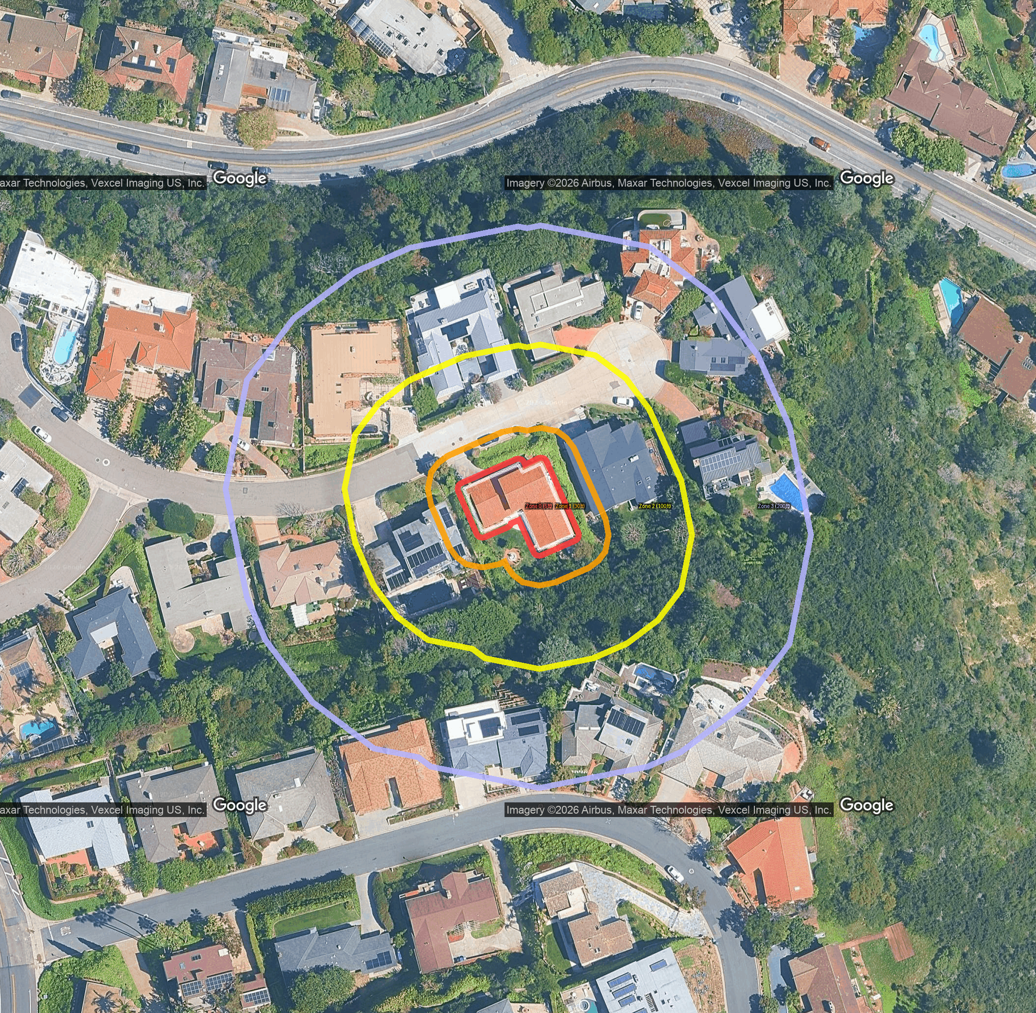
Defensible space zone analysis
Zone 0 shows good defensible space maintenance with primarily non-combustible hardscape surfaces. The immediate building perimeter appears well-maintained with minimal fire risk factors.
Weight: 40%
Zone 1 presents moderate risk with maintained landscaping and scattered trees. The combination of irrigated lawn and mature trees creates manageable fuel loading.
Weight: 30%
Zone 2 shows significant fire risk with dense continuous forest canopy and heavy fuel loading. The extensive tree coverage creates conditions for rapid fire spread and high heat generation.
Weight: 20%
Zone 3 represents critical wildfire risk with extensive continuous forest creating ideal conditions for fire initiation and rapid spread. This wildland-urban interface presents the highest threat level for ember generation and fire approach.
Weight: 10%
Zone Composite:
4.5
/ 10 (literature-calibrated weighted average)
Zone Zero Summary
The property shows moderate Zone Zero compliance with well-maintained immediate surroundings but significant risk from overhead tree canopy and vegetation in outer zones. The primary concern is overhanging branches and dense surrounding vegetation that could facilitate fire spread to the structure.
Neighborhood Score
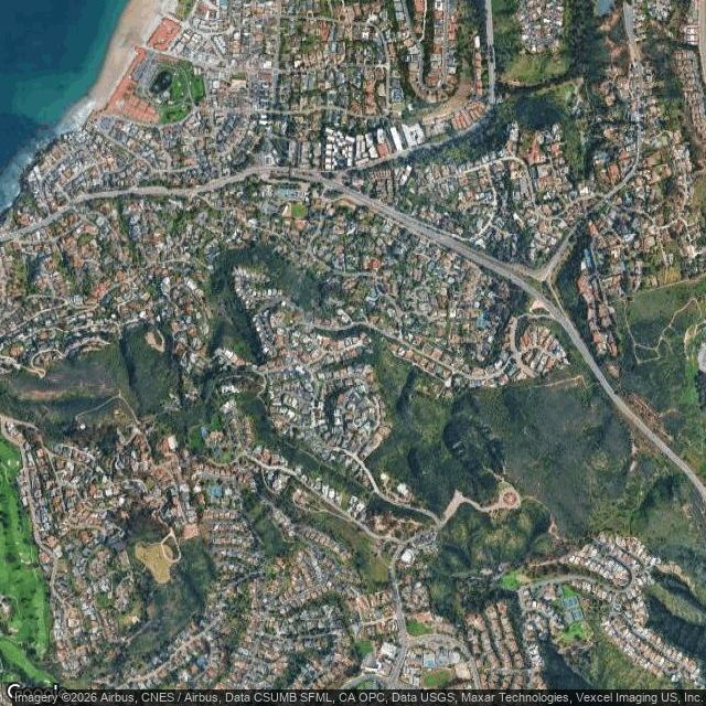
Neighborhood context
Click a factor to expand details. Scores: 0 = minimal risk, 10 = critical risk.
Property located in Very High Fire Hazard Severity Zone (LRA), representing the highest official fire risk designation
Weight: 15%
Located in Wildland-Urban Interface area with significant natural vegetation intermixed with residential development
Weight: 10%
La Jolla area has history of significant wildfire events with ongoing high fire risk potential in surrounding canyons
Weight: 10%
Mixed community compliance with vegetation management, some properties well-maintained while others show dense vegetation
Weight: 10%
No fire hydrants clearly visible in immediate street view, typical for residential suburban area
Weight: 10%
Standard residential street width adequate for emergency vehicle access
Weight: 7%
Moderate connectivity with some winding residential streets but multiple route options
Weight: 7%
Reasonable access to major arterial roads for emergency response and evacuation
Weight: 7%
Adequate evacuation routes available through residential street network to major roads
Weight: 9%
Multiple potential exit routes from neighborhood through various street connections
Weight: 9%
Property not located on dead-end street, has through-street access
Weight: 6%
Neighborhood Composite:
6.6
/ 10 (weighted average, location-adjusted ×1.25)
This property faces significant area-level fire risk due to its Very High Fire Hazard Severity Zone designation and Wildland-Urban Interface location. While emergency access infrastructure is adequate with standard residential streets and multiple evacuation routes, the official hazard zone designation and surrounding natural vegetation create elevated community-level fire risk exposure.
Wildfire Risk to Communities Data
Risk to Potential Structures: 0
(county mean: 14)
— Location risk multiplier: 1.25
Source: VHFHSZ + WRC (RPS=0)
Overall Risk Score Summary
4.4
Moderate Risk
0 — Minimal
5 — Moderate
10 — Critical
Weight Breakdown
Defensible Space
4.5 / 10
Your property's overall score of 4.4 indicates low wildfire risk. Targeted improvements can meaningfully reduce your exposure.
Local Conformity
Local Fire Codes
Property falls under LAFD and CAL FIRE jurisdiction with requirements for 100-foot defensible space per California PRC Section 4291. The 2020 AB 3074 Zone Zero law requires ember-resistant landscaping within 5 feet of structures. Local LAFD Fire Code Section 57.322 and 2025 CA Fire Code 4907.9.1 establish specific vegetation management and building requirements for Very High Fire Hazard Severity Zones.
Defensible Space Status
Defensible space is mandatory under state law with 100-foot clearance requirements. While the immediate structure area appears maintained, the significant overhead tree canopy and surrounding vegetation density suggest potential compliance gaps with outer zone clearance requirements, particularly given the Very High FHSZ designation.
Vegetation Risk
The property features typical Southern California chaparral and ornamental landscaping with significant fuel loading from mature trees creating continuous canopy coverage. The dense vegetation in surrounding areas combined with Mediterranean climate conditions creates elevated fire spread potential during Santa Ana wind events.
Community Programs
San Diego County participates in Community Wildfire Protection Planning with various defensible space inspection and education programs. CAL FIRE provides vegetation management guidance and enforcement, while local fire districts offer property assessments and community education on wildfire preparedness and defensible space compliance.
Compliance Gaps
Primary gaps include excessive overhead tree canopy that violates vertical clearance requirements and potentially inadequate fuel reduction in outer defensible space zones. The dense surrounding vegetation may not meet the clearance standards required for Very High FHSZ properties under current regulations.
Building Permit History
Year Built: 1971 |
Total Permits: 1 |
Fire-Relevant: 1
| Building Area: 2,760 sqft
| Lot Size: 13,500 sqft
Fire-Relevant Permits
| Date |
Type |
Description |
Status |
Value |
| 2019-12-18 |
Combination building |
Permit to an existing two story residence. Work to include minor demo on 1st and 2nd floor. Adding a great room, office space, garage on first floor with deck, second floor bedrooms, bathrooms, den, laundry room, with deck. Retaining wall city standard. |
in_review |
$51,047,800 |
Wind Risk Overview
The property shows moderate wind resistance with good structural elements including clay tile roofing and stucco construction. However, the dense overhead tree canopy presents the primary wind vulnerability risk through potential windfall damage during storm events.
Regional Wind Hazard Data
ASCE 7-22 Design Wind Speed: 0.0 mph (3-sec gust)
County: San Diego, California
Strong Wind Risk: 52.0 percentile (Relatively Moderate)
Tornado Risk: 64.4 percentile (Relatively Low)
Hurricane Risk: 8.3 percentile (Very Low)
Source: ASCE 7-22 + FEMA NRI
Structural Vulnerability Factors
Click a factor to expand details. Scores: 0 = excellent wind resistance, 10 = extremely vulnerable.
Hip roof design with some gable elements visible, providing moderate wind resistance with some vulnerable gable end areas
Weight: 14%
Clay tile roof appears in good condition for its age, with intact tile coverage and no obvious deterioration
Weight: 10%
Clay tile roofing provides excellent wind resistance with interlocking design and substantial weight
Weight: 8%
Standard residential garage door visible, appears to be single-car width which reduces wind vulnerability
Weight: 10%
Standard residential windows with no visible storm protection, typical for moderate wind climate
Weight: 8%
Stucco siding provides good wind resistance as a rigid, well-attached exterior finish system
Weight: 8%
Single-story structure minimizes wind pressure and overturning moments
Weight: 6%
Moderate eave overhangs visible, creating some wind uplift potential but not excessive
Weight: 7%
L-shaped footprint with moderate complexity, creating some wind pressure concentration areas
Weight: 6%
No solar panels visible on the roof structure
Weight: 5%
Dense mature tree canopy directly over and adjacent to structure creates significant windfall risk
Weight: 10%
1971 construction with apparent maintenance updates, moderate age with adequate upkeep visible
Weight: 8%
Structural Vulnerability Composite:
3.8
/ 10 (weighted average of 12 factors)
Wind Risk Score Summary
5.1
Moderate Risk
0 — Minimal
5 — Moderate
10 — Critical
Weight Breakdown
Structural Vuln.
3.8 / 10
Your property's wind risk score of 5.1 indicates moderate wind vulnerability. Key structural weak points should be addressed.
Wind Score = 40% Regional Hazard + 60% Structural Vulnerability.
Regional hazard data from ASCE 7-22 design wind speeds and FEMA National Risk Index.
Structural vulnerability assessed from property imagery using IBHS FORTIFIED standards.